|
|
Legality of Map Fonts
Map fonts are considered to be a special component of the map content, because although they are the most important explanatory element of the map, they have the lowest geometrical significance. The font gives additional information and helps reading the map. Generally, with fonts we can distinguish on the one hand between the aspect of mode and on the other hand by its meaning. The mode can vary in font face, size and any further graphical variation possible.
For example, in cartography with the variation in size, a differentiation in the meaning of certain objects in a group is possible, e.g. a smaller size could characterise a town with less inhabitants, a larger size more inhabitants.
This proposition can also proceed on the level of logic and its meaning. Then we need to split this logic and meaning aspects into a primary and secondary statement. See the example for clarification of this more theoretical content:
Now we have given you some aspects on how to theoretically differ names and important background knowledge you need in order to set up your lettering concept later on. But how explanatory is a map name if the user group it is created for cannot understand it? What do we mean by this?
Depending on the area, people tend to speak dialects or in a multi-language country, like Switzerland, different names for the one place exists. So we may say:
| In German: | Zürich | Solothurn | Neuenburg |
| In Dialect: | Züri | Soledurn | Nösch |
| In English or French: | Zurich (e) | Soleure (f) | Neuchâtel (f) |
| In Italian: | Zurigo | Soletta | etc. |
| In Latin: | Turicum | Solodurum | etc. |
For further information on lettering maps for Switzerland see the attached pdf file:
PDF_Letttering_Maps_of_Switzerland.pdf
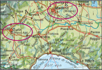
In your conception, you should take this into account. For e.g like you can visualise here:
 (Spiess 1993)
 Beneath this, take into consideration the name changes, due to e.g. political modification, liable for changed country names.
The principle for areas with latin scripting is, that names are written abiding its lettering. The rules of lettering are
adequate to the official writing in the specific country. Nowadays we try to reduce the use of ![]() exonyms.
exonyms.
The optional link below links you to the Wikipedia site with extensive lists of German exonyms for places in non-German-speaking
areas:
Lists of German exonyms
However sometimes, at the edge of language borders, compound names are accepted as soon as 30% of the minority of people are affected. For example, 'Biel’ could also be ‘Bienne'.
In areas where Latin is not the base of the language, e.g. Greek, Hebrew, Chinese or Indian, we can just paraphrase the names.
They can either be ![]() transcribed or
transcribed or ![]() transliterated. Therefore special tables exist for any language.
transliterated. Therefore special tables exist for any language.

