GITTA-Logo
PDF Version of this document Search Help Glossary

Lesson Navigation IconLayout Design Settings / Graphical Semiology

Unit Navigation IconMap Size and Scale

Unit Navigation IconDefinition and Organisation of Map Elements

LO Navigation IconDefinition of Map Elements

LO Navigation IconOrganisation of Map Elements

LO Navigation IconInternal Organisation of Map Elements

LO Navigation IconHierarchic Organisation 1

LO Navigation IconHierarchic Organisation 2

LO Navigation Icon Hierarchic Organisation 3

LO Navigation IconThe Golden Section

LO Navigation IconFocus of Attention

LO Navigation IconConstruct your Map

LO Navigation IconSummary

Unit Navigation IconTypography

Unit Navigation IconColour Design

Unit Navigation IconReadability Rules

Unit Navigation IconMap Critics

Unit Navigation IconSummary

Unit Navigation IconRecommended Reading

Unit Navigation IconGlossary

Unit Navigation IconBibliography

Unit Navigation IconMetadata


GITTA/CartouCHe news:


Go to previous page Go to next page

Definition of Map Elements

A map usually contains the following elements:

Title (and subtitle):
Usually draws attention by virtue of its dominant size; serves to focus attention on the primary content of the map. Should be an answer to "What? Where? When?".
Tips: Never underline a title (or a subtitle), and never put a colon after a title.

Legend:
The principal reference to the map symbols; subordinated to the title. However, this is still a key element for map reading; describing all unknown or unique map symbols used.
Tips:Only the word "Legend" should be written on your map (and not "Map Legend", or "Switzerland Legend", etc.).

Map Scale:
Provides the reader with important information regarding linear relations on the map. A scale can be numerical (for example 1:50000) or graphical.
Tips:The dimension and thickness of a graphical scale has to be adapted to the map content.

Credits:
Can include the map source, the author, indication of the reliability of accuracy of the map, dates, or other explanatory material.
Tips:Credits should always be written smallest as possible (but nevertheless readable) and be placed in a box without a frame.

Mapped Areas:
Objects, land, water, and other geographical features important to the purpose of the map.

Map Symbols:
Wide variety of forms and functions; the most important element of the map, along with the geographic areas rendered.
Place name and Labelling:
The chief means of communicating with maps; serve to orient the reader on the map and provide important information regarding its purpose.
Tips:Use the same font for the map frame, the map layout, and the map content.
North arrow:
According to the rules, each map should have a north arrow. But if the map is north oriented, or if the geographical co-ordinate are already on the map the north arrow can be omitted.
Tips:The north arrow must be well readable, but not be too dominant on the map.
Border and Neatlines:
Both optional; borders can serve to restrain eye movements. Neatlines are finer lines than borders, drawn inside them and often intra-parallelism, rendered as part of the graticule; used mostly for decoration.
Graticule:
Often omitted in maps today; should be included if the location information is crucial to the map purpose, e.g. into topographical maps.

In the following example, you can observe a map which, consists of the different map elements discussed.

Example of map elements presentation (Student work, ETH Zurich)Example of map elements presentation (Student work, ETH Zurich)

Since you know now all the elements that constitute a map, you have to learn how to arrange them.
On the following map, try to find out visually all the cartographic elements presented previously. This exercise is not evaluated.

Expo 02 : Map of Morat 
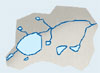
Expo 02 : Map of Morat (Expo 02)
Top Go to previous page Go to next page