|
|
![]()
Map Size
Choosing a good and appropriate map size is not simple, as it depends on many factors. You should take most of these factors into consideration before choosing your definitive map size. The factors affecting the map size are:
- The map medium. Very often, it is this first factor which affects the final decision about the map size: you can not make
a A0 map for a newspaper map, or a A5 map for an informative paper map such as a poster. The map size will not be the same
for the following media:
- Paper maps
- Newspaper maps
- Screen maps
- TV maps
- Web maps
- The print costs. The costs are not the same for an A4 map than for an A0 map (which is much more expensive). So also take the print costs into account.
- How many variables are to be mapped? Would it be better to do several maps with few variables, rather than one overloaded map?
- Will the map be foldable? Can map information be written on the map back? If yes, you can choose a smaller size than predicted.
You need to know all the answers of these questions, in order to determine the map size. You need to know all the answers of these question in order to determine the map size. Generally, a rectangle with sides having a proportion of about three to five seems to be a pleasing format. Another good solution to size your map is the Golden Section method. This method will be explained in the unit "Definition and Organisation of Map Elements ".
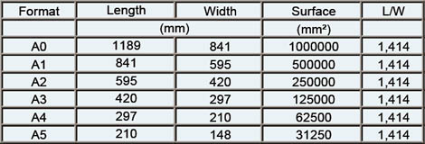
The most used formats for paper maps
The sheet of 1 square meter of international normalised format is represented by the symbol A0, half a sheet by A1, and a
quarter of sheet by A2. The proportions of these sheets are such as they allow to keep the same proportions when folding along
the smallest of the medians.
The following example shows you the numerical and graphical relationship of these formats. Roll with your mouse over the various
formats to see it graphically at the scale 1:10.
|
|
|
|