Exploitation of geographic information
The exploitation of geographic information is
aimed for exploring, modelling and forecasting spatial processes
from the model of reality. This is where Spatial Analysis (SA)
takes place. However methods of spatial analysis are already used
for the construction of geographic information, mainly during the
conditioning stage for regionalisation purposes. The spatial dimension
of information allows
original and rich components belonging to the reality.
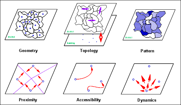
Components of the spatial dimension to be exploited with spatial analysis
|
|
Exploration and modelling objectives are embedded
in the organisation of B-AN Lessons. Their contents are structured
according to the nature of phenomena and to exploitation tasks.
According to the objectives of the exploitation, space and its
spatial relationships can be modelled in different manners, from
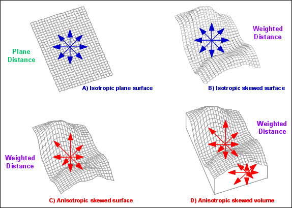
a “simple” homogeneous surface to a heterogeneous volume with
anisotropic properties:
- As an isotropic plane surface:
space is simply considered as an homogeneous surface with thematic
property distribution only ruled by euclidian geometry (linear plane distance
influencing accessibility, proximity and dependency).
- As an isotropic skewed surface:
space is considered as an heterogeneous surface with each location
influencing differently the distribution of thematic properties as
well as the proximity and the accessibility. Space is modelled as a
skewed surface expressing an individual “isotropic friction rate” at
each location. Distance is therefore no longer linear but symmetrical.
- As an anisotropic skewed surface:
space is considered as an heterogeneous surface but with an individual
“anisotropic friction rate” at each location. Distance is therefore no
longer linear nor symmetrical.
- As an anisotropic skewed volume:
space is considered as a volume rather than a surface. Distribution
of properties are modelled in 3 geometrical dimensions, sometimes
required for analysing atmosphere, hydrosphere or the lithosphere.
Modelling spatial properties in different manners
|
|
Exploration of geographic information (B-AN, B-PR)
What is the spatial distribution of properties throughout
the study area? What are relationships between spatial features and
within their thematic properties and their change?
To answer to these rich and complex questions,
one needs to consider the nature of spatial distributions and
the objective of exploration for the design of an appropriate exploration process:
- The spatial distribution of phenomena according
to their nature (continuous, discontinuous). Tools and
methodologies to describe their distribution and to relate properties
of spatial features (B-AN Lessons 2
and 3)
- How to describe relief properties of space based on its elevation
properties (DEM)? Numerous methods for deriving relevant indicators of
relief and for partitioning space into terrain features (watersheds,
shape types ...) are proposed. They are terrain analysis methods
(B-AN Lesson 4)
- The selection of spatial features or the description of
their specific properties. Spatial Query is certainly the most
obvious but also the most frequent exploration objective.
It allows selecting spatial features from the GDB based on various
thematic and geometric criteria. In object mode spatial query makes
used of powerful tools proposed by SQL and GQL languages features
(B-AN Lesson 5 and
B-DM Lesson 4).


