|
|
Map User’s Feedback
Map user’s feedback is helpful to the map author in that it allows him to alter the design by incorporating changes suggested by the map user. Unfortunately, most cartographic designers are separated from users by time and space, so it is difficult to make use of such feedback.
User should also describe how the map will be used. Legibility requirements for road maps to be used in a moving car must be higher than for a map to be viewed in stable conditions. Maps to be used at night in boats, ships, and aircrafts must be usable in dim conditions so that night vision will not be greatly affected by bright illumination. A map on a wall being viewed by an audience seated at desks will require a different treatment of graphic character than a map of the same sort in a textbook on the desk. If you are not sure about the "map user feedback"a good question which is necessary to be answered before continuing is: "have I well understood the needs of the map user"? If the answer is negative, you should discuss the map user again, or have a look back at the unit "map types" to get more information about the different map types.
It is also still necessary to pay attention to ethical questions regarding map making. Indeed, a map should never contain purposeful errors (lies) or poor judgement, even if the map client asks for it.
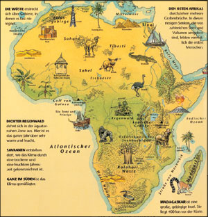
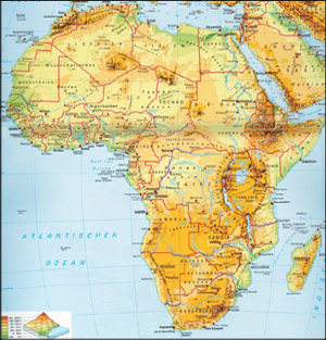
As an example of map user’s feedback, look at the two following school maps showing the African continent. The first map on the left is designed for children between 5 and 9 years. The map designer takes the small capacity of comprehension of young children into consideration to design this very uncomplicated and attractive map: few colours, pleasing children symbols, little thematic information. The more detailed map on the right is designed for children between 10 and 15 years. This map is much more complex than the first, but still simple: only relief information, border, toponimy information and sea names are represented.
 Map for children between 5 and 9 years (Michel et al. 1998) Map for children between 5 and 9 years (Michel et al. 1998) |
 Map for children between 10 and 15 years (Klett-Perthes 1993) Map for children between 10 and 15 years (Klett-Perthes 1993) |
