|
|
The idea behind GITTA
The motivation within ![]() GITTA lies in exploiting synergies, increasing the teaching capacity as well as improving
the quality by redesigning the course on a modular basis to offer high flexibility.
That means: flexibility in time and content to be chosen, individually adapted to
the students needs, where theory is no longer separated from practical experiences.
GITTA lies in exploiting synergies, increasing the teaching capacity as well as improving
the quality by redesigning the course on a modular basis to offer high flexibility.
That means: flexibility in time and content to be chosen, individually adapted to
the students needs, where theory is no longer separated from practical experiences.
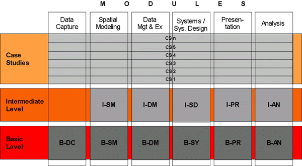
The idea behind GITTA is to supplement, and partly substitute, the actual GIS education by internet based learning modules. Its organization is modular and divided into two levels complemented by case studies:
- Basic Level: Foundations and basic methods in each technical domain are introduced. Each of the 6 GITTA modules offers between 3 to 7 basic level lessons. In total GITTA consists of 29 basic level lessons.
- Intermediate Level: The knowledge of the basic techniques is further developed. The level of abstraction is higher. The tackled techniques move from a general point of discussion down to a specialized level. All modules except for the data capture module offer intermediate level lessons. In total GITTA plans to have about 20 intermediate level lessons available.
- Case Study: Accompanying the learning units, real world case studies are an essential part of every level of learning; focusing on deepening the theoretical knowledge in a case based and interdisciplinary form of studying GIS. Conceptual formulations are aligned so that students can prepare their individual work based on knowledge of the level they have completed. In total about 10 GITTA case studies are planned.
The learning environment is designed to be flexible to meet the users requirements and to apply learning material either class-accompanied, or, for self-guided studying. Great emphasis lies on adding a surplus value to this way of education, and, the idea is to give the students the possibility to discover GIS concepts interactively on their own.
The project organization is built up by six modules as you can retrieve from the following graphic:
 The six available GITTA modules
The modules are educational components which bound a specific field of knowledge and lead to well-defined expertise and skills. Each module touches a number of methods and techniques as well as their applications. The six modules cover the following topics (see also illustration above):
- Data Capture
- Spatial Modeling
- Data Management
- Spatial Analysis
- Cartographic Data Presentation
- Geographic Information Systems/Design
Each of these modules are made of three to seven lessons. The entire course organization is modular down to the lesson level, what means that the choice of content to be integrated in a course can be made on this level. This guarantees in-depth information in small learning units that can be successfully completed step-by-step, as well as guaranteeing high flexibility whereby a clear learning target is defined to the student.
The smallest building block is the Unit. Units are based on the ![]() ECLASS model, which is described in detail on the next page about the pedagogical concept behind GITTA.
ECLASS model, which is described in detail on the next page about the pedagogical concept behind GITTA.
