Extraction of topographic information
The terrain plays an important role in many spatial models. In a GIS, the information about altitude is stored in digital terrain models. In this unit, we learn how to derive information from digital terrain models and how, and in which context, it is used.
 The terrain plays an important role in many spatial model (Photo: Ross Purves)
Grid vs. TIN
In a digital terrain model, altitude values are usually organized in one of these data structures:
- Grid
- TIN
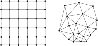
The structures of grids are similar to raster data sets. Each rectangular grid cell has the same size. The altitude is stored in each of these grid cells. This data structure is the most widely used structure, due to its simplicity and easily implemented algorithm. However, the disadvantage of a grid is that density cannot be adjusted to the complexity of the terrain. For that reason there are often too many data used for the representation of simple terrains.
TINs consist of irregularly distributed points. The triangles are built up on these points. This data structure allows for the efficient storage of terrain information; the triangulation allows a variable density and distribution of points. It can be adapted to more complex terrain (more data points at complex terrains and fewer points in flat areas of the terrain). It is more complicated to implement these algorithms than to implement algorithms based on raster data.
 Grid (left side) and TIN (right side)