|
|
What is a Map by Legal Order?
Article 38 of the "appendices to Swiss Civil Law (ZGB) ", authorizes the Swiss Government to define a "basic plan for land registry and surveying". Furthermore, article 39 defines that the Confederation has to contribute the major part of the costs for cadastral surveying, whereas the smaller part of costs has to be shared between the Confederation and the Cantons. These articles are to be applied by the Federal Office of Topography (external link).
Legal cartography is not only limited to the mentioned examples in this learning unit. Another example is, for instance, land registry, which is a legal cartography of the ground ownership that is used in rather large scales. Thus, legal cartography can be considered as a cartography that is administrated by the government.
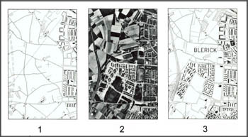
Revision of a Topographic Map
In Switzerland, the revision of the national topographic maps is periodically (every six years) done by the Federal Office
of Topography (International Cartographic Association 1984).
The example shows a revision of a topographic map 1:25000 of Blerick county (Great Britain).
 Topographic map revision (International Cartographic Association 1984) Topographic map revision (International Cartographic Association 1984) |
|
Hazard and Risk Maps
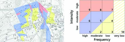
Spatial planning measures (alignment of land-use with natural conditions) can significantly reduce damage potentials. Hazard maps form the basis for these spatial planning tasks by indicating the location of hazard prone areas. Hence, many governments (e.g. Switzerland, Colorado, and many more) passed laws that make the generation of hazard maps legally binding.
In Switzerland, hazard maps encompass rock fall, mass movements, snow avalanches, and flooding. Potential hazardous processes are assessed and assigned to hazard zones based on the frequency and the intensity of hazardous events. These zones encompass the following four levels:
- Red: Considerable danger
- Blue: Moderate danger
- Yellow: Low danger
- Yellow/White Hachure: Residual danger
 Hazard map and corresponding frequency-intensity diagram (Kunz 2011)