|
|
![]()
Description of the Term "Spatial Analysis"
The definition of the term "spatial analysis" raises some problems, as stated by Bailey:
"One difficulty experienced in any discussion of links between GIS and spatial analysis is clarification of exactly what is to be considered as spatial analysis. The problem arises because, by its nature, GIS is a multi-disciplinary field and each discipline has developed a terminology and methodology for spatial analysis which reflects the particular interests of that field. In the face of such a diversity of analytical perspectives, it is difficult to define spatial analysis any more specifically than as: a general ability to manipulate spatial data into different forms and extract additional meaning as a result" (Bailey 1994, p. 15)
This means that the questions and methods of spatial analysis grew "naturally". They have
been developed in various sciences related to GIScience, which focus on different interests
and topics of investigation. For example, a distance query to reveal all ski resorts within a
certain distance could be a simple data retrieval for some, but for others a query could
represent a complete spatial analysis.
The attempt at a definition fails. There is no possibility to define the term of spatial
analysis but only to describe it. In order to give an idea, the following descriptions can be
mentioned:
"A general ability to manipulate spatial data into different forms and extract additional meaning as a result." (Bailey 1994, p. 15)
"In broad terms one might define spatial analysis as the quantitative study of phenomena that are located in space." (Bailey et al. 1995, p. 7)
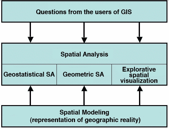
The next section offers a wider and more complex view on the term "spatial analysis", which can be given various meanings. But first the position of SA in the GIS context should be discussed. There are the two major streams within quantitative SA: geometrically oriented and geostatistically oriented. A third stream, visual data analysis, recently arose. It is well known that maps can provide information about spatial patterns and processes (more details are provided in the module "Basic Presentation"). These three streams mentioned can be characterized as follows, using different approaches:
- Geometric SA:
- The geometric approach is focused on geometric criteria (location of objects and attributes), and has mainly a descriptive effect. It cannot be used for hypothesis testing. Some examples using geometric SA include: the analysis of point distributions, network analysis (route calculation, shortest path), polygon overlay, analysis of distance relations, shape analysis, or the calculation of slope and exposure in elevation models.
- Geostatistical SA:
- The geostatistical approach refers to spatially distributed (random) variables. This approach uses statistical methods for description but also for hypothesis testing. Some examples using geostatistical SA include: multivariate statistics, spatial correlation analysis (spatial autocorrelation), and geostatistical interpretation.
- Explorative spatial visualization:
- This is a purely visual approach, in visualization as well as in interpretation. Visualization is a qualitative and explorative method to explore new data, to identify outliers and to formulate hypothesis.
These combined approaches offer a range of possible methods in spatial analysis as shown
in the following image. Spatial analysis is not used as an end in itself but to get answers.
Therefore, methods to represent phenomena and processes are needed but also
appropriate methods to analyze these phenomena and processes. That means that a direct
relationship exists between the methods of modeling and representation of geographic
reality and spatial analysis techniques. The methods of spatial modeling and their impact
on spatial analysis are discussed in the module "Basic Spatial Modeling".
|
|
|
|