|
|
![]()
Roots of Spatial Analysis in GIS
Despite their central role in geographic information systems, most spatial analysis methods emerged before and independently from GIS technology. Most of these methods have been integrated later into the GIS technology. GIS platforms provide several functions such as data acquisition, data management and visualization. The combination of these functions with analytical operations makes them even more efficient.
The origin of spatial analysis, known in the context of GIS of today, goes back many years. A selection of early articles about spatial statistics and quantitative spatial analysis is provided in the reader written by Berry et al. (1998). Some of these articles were written in the 1930s, but most of them were written in the 1950s and 1960s. The use of statistical and other quantitative methods for the analysis of spatial patterns and processes were especially prominent and developed in spatial sciences, which focus on the analysis of those spatial patterns and processes. Examples of such disciplines are regional science, quantitative geography or landscape ecology. In geography, the use of quantitative methods was coupled to a change of paradigm, called the "quantitative revolution". This trend was particularly pronounced in the 1960s and 1970s. It is well described in the books written by Abler (1971) as well as by Haggett (1965) and Haggett et al. (1977). At that time, geodetic sciences did not focus on the development of SA methods. However, since the 1980s, as GIS became a more integral platform, there was a growing convergence of methods used in SA involved in the development of GIS technology sciences. This development is well illustrated in the book written by Bill (1999).
With his background in geomatics, he devoted a large part of the content to data analysis, focusing specifically on SA . But which methods were developed before the advent of GIS technology? As stated in Fisher (1999), these were mainly quantitative methods for the characterization and analysis of:
- Patterns (e.g. distribution and arrangement)
- Shapes of geographic features (points, lines, areas and surfaces).
Initially, a geometric approach dominated the field, which was particularly concentrated
on point pattern analysis as well as the characterization of networks. Later, the focus
changed to the development of methods. The analysis of the intrinsic properties of the
geographical area (e.g. the relative distance between spatial objects), processes of spatial
preferences (e.g. positioning of shopping centers) and the analysis of spatial interactions,
became more important in the development of methods. Within this time of
development, methods of multivariate statistics were increasingly used and adjusted to
the needs of spatial science; standard statistical packages have been linked to GIS for
exploratory data analysis, statistical analysis and hypothesis testing. Examples for such
statistical methods are stated below:
- Regression analysis
- Principal component analysis
- Linear discriminant analysis
- Trend surface analysis
As these methods were developed in other disciplines rather than spatial science, their use
in spatial related analysis caused several problems as these methods did not take spatial
heterogeneity or spatial dependence of samples distributed in space into account. As a
consequence, methods for geostatistical analysis were developed from the late 1960s that
perform better with spatially related data.
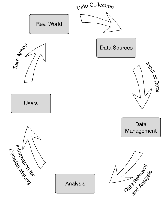
By the late 1970s, geometry‐oriented operations of spatial analysis (e.g. spatial query, point pattern analysis, polygon overlay, buffering etc.) and methods of geostatistical analysis were being made available in GIS. These days, typical commercial GIS packages provide a wide range of functions for geometric and geostatistical analysis. A big advantage of the incorporation of analysis functions in GIS is the connection between the tools of data acquisition, data modeling, data management and visualization. This enables the entire cycle of spatial data processing to be completed using one software to answer complex questions.
|
|
|
|